
C-MAP MAX NA-M024 – U.S. West Coast & Hawaii – SD™ Card
$279.00 $251.10
| Weight | 0.1 lbs |
|---|
NA-M024 => USA West Coast and Hawaii
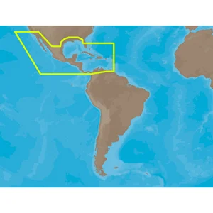
Coverage of the Pacific Coast of the United States, including all of the coasts of California, Oregon and Washington. Coverage of Baja California and Mexico down to Puerto Vallarta. Detail of the Columbia River, Sacramento River, Willamette River. Snake River and San Joaquin Rivers are also included. Full coverage of Puget Sound and the San Juan Islands up to Point Roberts is also included. Additional coverage of the Hawaiian Islands out to Midway and Johnston Atoll is also included.This product may not be returned to the original point of purchase. Please contact the manufacturer directly with any issues or concerns.


⚓ Smooth Sailing Shipping
Enjoy FREE standard shipping on most orders over $250 within the continental U.S. (excl. heavy/oversized/hazardous items).
We ship via UPS, FedEx, and USPS . Orders are processed in 1–2 business days with typical delivery in 1–5 business days .
🧭 Track The Voyage
You’ll receive tracking info by email once your order ships. If your package is marked “delivered” but not received, please wait 48 hours then reach out to our team.
🛟 Hassle-Free Returns & Exchanges
Returns accepted within 30 days of delivery. Items must be unused and in original packaging.
- Mistaken or damaged cargo? We’ll handle return shipping.
- Changed your course? Return shipping is on you.
- Report defects or damage within 7 days for a free exchange.
💰 Anchor Your Refund
Refunds go back to your original payment method within 5–7 business days after inspection.
📨 Contact the Crew
Questions about your order? Drop anchor at sales@marineelec.com .


